The History of Boddington
A relatively young town, Boddington was originally gazetted in 1912. The name Boddington comes from Henry Boddington a shepherd who grazed his sheep on the banks of the Hotham River in the late 1800's. A pool in the Hotham River, which Henry frequently camped at had been named Boddington Pool by the early settlers. Henry Boddington later settled in the Great Southern Town of Wagin. European settlers first came to the district in the early 1860's. The district had several localities, Marradong, Crossman, Hotham, Camballing, Lower Williams, Quindanning etc.
Dilyan an aboriginal belonged to a tribe, which lived within the boundaries of Wandering and Williams. Dilyan travelled with explorer, Sir John Forrest and was so highly regarded that he presented him with a silver mounted and inscribed fowling piece (gun), as well as naming a spring at the Cambridge Gulf in the North-West of Western Australia after him. Dilyan, rendered sterling service on a survey expedition, led by Mr. R.S. Ranford, Dilyan's grave is on the Bannister/Marradong road approximately 5km south of Boddington, is marked by a Royal Historical Society plaque which visited Cambridge Gulf in the 1880's and marked out the town of Wyndham, as well as effecting other important surveys.
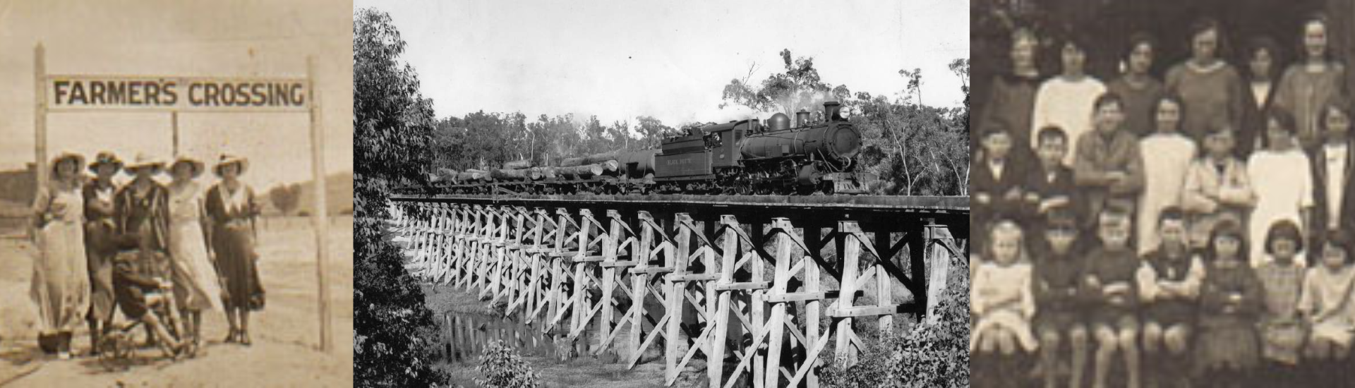
The Hotham was the locality originally settled by the Farmer family. Nearby a school was built on the banks of the Hotham River. The area is still farmed by the Farmer family but the school closed on 20th September 1920 with the coming of the new school in Boddington. The area is located at the end of Farmers Avenue, to the West of the town with the Hotham River School on Palmer Rd.
The rise of the timber industry saw the construction of the Railway Line from Dwellingup to Boddington that eventually linked with Narrogin to the east. A railway bridge was built over the upper reaches of the Murray River in 1949, then known as "Asquith Bridge", and was used for carting railway timber to the Banksiadale Sawmill.
Marradong became the centre of the district with the local Road Board being founded there in 1892. In 1961 the Marradong Road Board was renamed as Shire of Boddington. Marradong once boasted a shop, post office, hotel, church and a one roomed school. The only remaining structures are St Albans, the centenary old church, and a few older establishments. Marradong was the centre of Local Government until 1925 when a building was built in Boddington for their office. This building still stands in Johnstone St, next to the Town Hall. Marradong was settled by the Batt family.
Ranford, a small settlement 4 kilometres east of Boddington, was established in later in the 1930's as a result of the Tanin Extracts Factory. Although Ranford had a boarding house it relied on Boddington for its services.
Hotham River School
The only remaining features of this site are a huge old Blue Gum Tree and an old Pine Tree. The school is long gone. Located on the banks of the Hotham River, on Palmer Road near where Eliza & Thomas Farmer had originally settled in 1864.
The original building was built of mud bricks which were fired on or near the site. It was a single class room with one teacher. The last teacher, Arthur Sharpe, built a house nearby called 'Trentholme', after the area of England where he had came from.
The Hotham River School closed on the 20th September 1920 and then the 'new' School opened the next day. The 'new' school was built in the newly gazetted town of Boddington, which was expanding due to the coming of the railway.
1921-1999
1999 saw the decommissioning of the old weather board & fibro school. The school located near the centre of town overlooking Lions' Weir on the Hotham River, was first opened on 21st September 1920. This is being replaced by a new ultra modern building opening for the beginning of the year 2000 school year, with a number of its facilities being shared with the community.
The old school was originally built to meet the needs of the newly gazetted town, which was expanding due to the coming of the railway. Previously another single roomed school had served the community some 3 miles (Approx. 5 km) downstream on the banks of the Hotham River on Palmer Road, near where Eliza & Thomas Farmer had originally settled in 1864. The Hotham River School closed on the 20th September 1920 and the then 'new' School opened the next day.
The first one-roomed building was clad entirely of weatherboards. It was a high walled building with a large brick chimney. This chimney was a favourite place for youngsters to bounce balls on. The architecture of this building is maintained throughout the entire complex. An original platform from the 1920's room was removed in the 1942 relocation.
Boddington's history shows a constant need for more schoolrooms. During the 1930's a second class room was built. Boddington State School as it was known, remained a 2 roomed school until 1942 when the original 1920 room was moved, extended and incorporated into the building of another classroom which forms part of the structure existing today. Further additions were made in through to the late 1950's. The distinctive front facade of the school was part of the 1948 extensions.
The old school and surrounds combine to make a unique entrance to Boddington. The original U shaped complex is ground level at the Bannister Road frontage and is raised on wooden stumps over 2 metres high at the rear.
Tannin Extracts Factory
The Tannin Extracts Factory, situated at Ranford, was officially opened on the 21st April 1937, by the Lieutenant Governor Sir James Mitchell. The factory processed White Gum timber, extracting the tannin.
The process of extraction used was said to be second only to that from chestnut trees in the Adriatic region for tanning leather. Logs up to ten feet in girth and eleven feet six inches long were taken and fed end-wise into a machine called a 'hogger' which clipped it. Within the revolving drum, alternately smooth and serrated blades took chips off the log in a transverse section, thus opening up the cells of the wood to allow it to be leached. One resident likened it to a giant pencil sharpener. In the still of the night noise of the hogger could be heard even in the town of Boddington about two miles away.
The chips were treated with water & steam and then leached for 24 hours. Liquor from this operation was pumped to copper tanks for a separation process, which evaporated off the water and dried the residue. The finishing pot held 4 tons of extract. This was raked off, bagged and transported from town by train.
Operation of the works brought an influx of people to the district and created opportunities for many locals whose prospects otherwise were meagre in the post-depression era.
By 1939 the company decided that demand for its product was such that a second factory of equal size with the first should be built. During the war years workmen in Boddington operated a round-the-clock shift, seven-days-a-week schedule, including quick shifts and double shifts to cover the shortage of labour and to meet the demand for tannin extract.
In 1957 after 20 years of service the first plant was closed down. Twenty years of intense operation, at three-shifts per day, had worn it out. The last whistle blew at the 'No 2 Factory' on the 20th March 1964. The plant was worn and the timber supply near exhausted.
Both of the mills were removed and the only original building left is the Offices, which is now a private dwelling.
Referenced: Becoming Boddington, John Ferrell.